IMG. 1.1
As seen on MEGABLOG, studies of a trans-global highway and pipelines began to lead the project towards a speculative global transportation network.

IMG. 1.2
In the mapping phase of this studio, the idea of world travel was developed through a series of travel time mappings. A new world was drawn with location based on time distance rather than geographic distance from one of three "hubs"--NYC, Tokyo, and London. (The mappings may be seen here.)
Continuing with these three global cities as sites for a physical proposal, the project then moved towards a physical proposal that streamlined travel between NYC, Tokyo, and London: Tubes passing through the earth as opposed to following the curvature of the earth that would provide trans-national direct train travel.

IMG. 1.3.1
This idea brought up many questions as to (obviously) the feasibility of such an idea, but also as to the politics of joining nations by underground tunnels. Research of the Chunnel which joins the UK and France may be seen here. This brought further questions as to the politics of tunneling through the earth--who owns the underworld?

IMG. 1.3.2
As to the feasibility of tubes passing through the earth, a knowledge of the physics of traveling in these tubes was necessary. Robert Hooke studied the motion of a body passing through the earth in his theoretical Gravity Train, (diagram above) in which a body accelerated as it fell into a frictionless hole through the earth and then decelerated upon passing the center of the earth until in came to a stop on the other side of the earth.

IMG. 1.3.3
To reduce friction, magnetic levitation trains in a vacuum tube would be ideal. A trans-atlantic mag-lev train tube is currently being researched that would be submerged in the atlantic to allow supersonic train travel.

IMG. 2.1
Comparison of travel distance through tubes versus over land by plane.

IMG. 2.2
A cross section of Earth with the tubes in place.
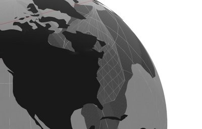
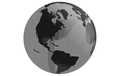
Using the same methods in the 2D travel time maps above, a 3D map of the new world was produced that is a visualization of the effects of the tubes on travel efficiency. With NYC selected as a hub, the globe was modeled with the areas around London and Tokyo sunken in to create massive holes. The diagrams below are sections of this theoretical globe where you can see the shrunken space between the cities as a result of the reduced travel time.

IMG. 2.3

IMG 2.4
3D mapping/model.
Animation of new world.

IMG 2.5
Occupying the "new world" from inside the NYC-London "hole."

IMG 2.6
Inside the NYC-Tokyo "hole."
In previous research, the use of the excavated material from the tube drilling came into question. The image below shows the amount of material that would be extracted in the process of drilling these tubes.

IMG 3.1

IMG. 3.2
This is a speculative image of the Hudson River filled in with the displaced material. Manhattan Island is no longer an island. Similar studies could be done for the displaced earth in Tokyo and London (also located on islands.)


