Friday, December 01, 2006

Update 12-01

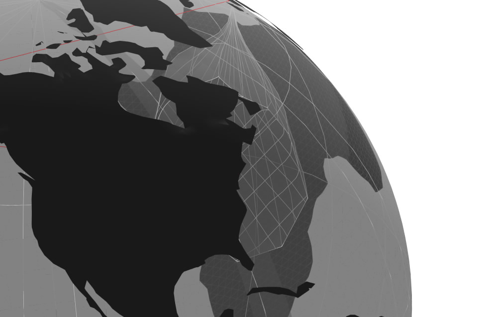
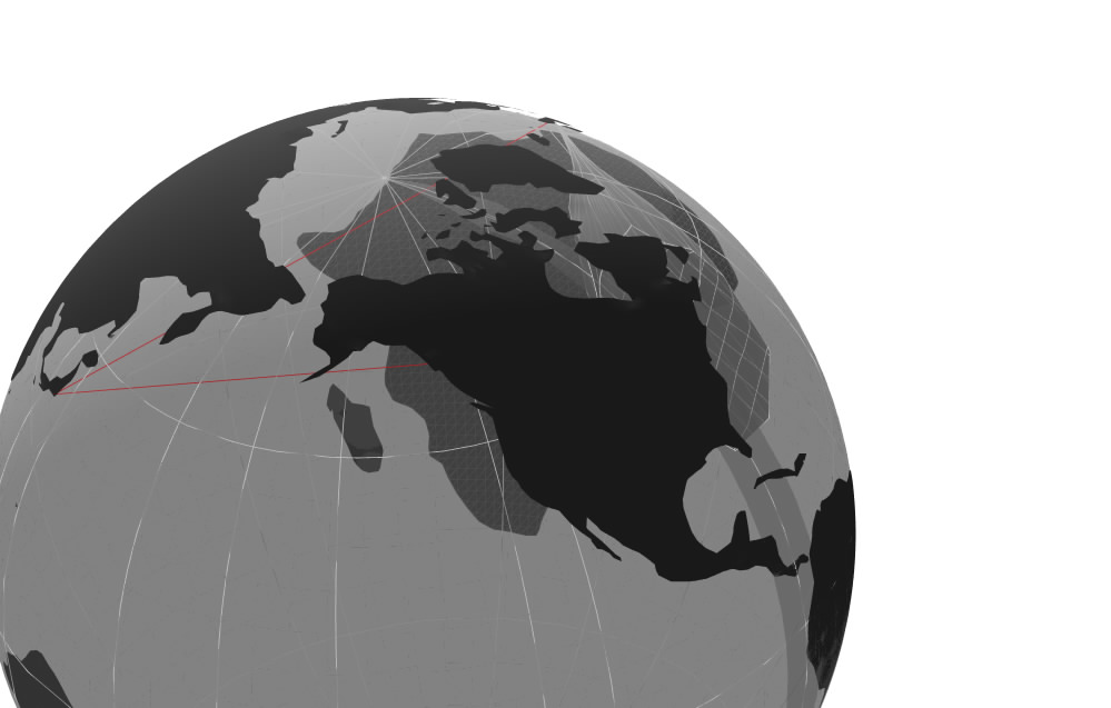
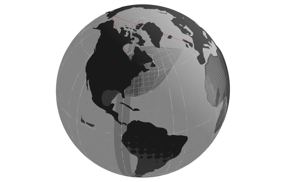
Modeling a distorted globe in FormZ has proved more difficult than I imagined. Here are some work-in-progress images:


I am experimenting with using the S-Loft tool to create a shape the size of the "hole" I wish to create and then differencing this from the sphere. I would like the hole to be more organic and pull the land around it instead of just subtracting it. I would appreciate suggestions on methods and tools to do this.

Wednesday, November 29, 2006

Desk Crit 11-29

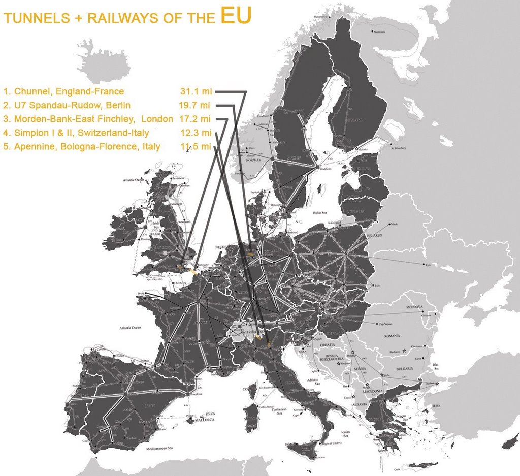
To study the use of direct tunnels in a more localized area, I have chosen to focus on the effects of this approach in the European Union. Since I am concerned with rail transportation, below I have traced the existing railways of the EU as well as the top five longest tunnels.


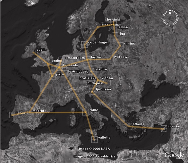
In the next image I have drawn speculative tunnels connecting the capital cities of countries in the EU.


I hope to compare the existing rail travel in the EU with my proposal of direct-route tunnels using the same methods as I used witht the travel time maps.

Monday, November 27, 2006

Research 11-27

Politics of joining nations with tunnels:

Chunnel--approximate 50-50 split in responsibility for construction and costs. Begun from both UK and French coasts and met in middle. Customs and border controls are implemented at opposite ends of tunnel. (You are considered on your destinations country's ground upon entering the train.) The trains are managed by an international joint operation between France, UK, and Belgium called Eurostar.

Why Tunnels?
  • Less impact on land than bridges--ends of bridges require much more land
  • Less impact on environment than bridges--allows for reclaiming of land, controls/lessens pollution
  • Safer in some cases--Seikan Tunnel in Japan was built after over a thousand people died after a typhoon sunk ferries crossing the Tsugaru Strait
  • Direct travel
Gravity Train:

Robert Hooke, when studying gravity, hypothesized with Isaac Newton about an unobstructed object passing through the earth that would accelerate at a high velocity and then begin to decelerate once it passed the center of the earth. The deceleration would cancel out its acceleration so that it would come to a gentle stop on the other side of the earth. It would take exactly 42 minutes and 12 seconds to travel from one side of the earth to the other from practically any location. The shorter the distance, the lower the velocity, and thus the more feasible this method of travel would be for humans. On BBC, a writer hypothesizes that the same principle would apply to distances as short as 1/6 of the earth's circumference--4,150 miles.

Check these out for more detailed descriptions: YouTube, Wikipedia, Damn Interesting.

Monday, November 20, 2006

Presentation 11-20-06

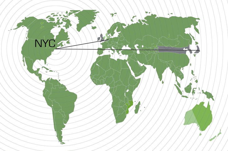
I am moving towards a global transportation network visualized in four dimensions. Right now I am focused on direct tunnels connecting the three global cities NYC, London, and Tokyo, that would provide passenger and freight access via high speed rail.


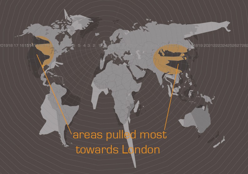
I chose my site based on interpretations from the mapimations. I noticed that in the London map, (which I believe is the most accurate of the three), East Asia and the US feel the greatest "pull" towards London. You can see this in the highlighted areas of the map above. I believe this pulling is due to the frequency of travel to these locations and the number of direct flights available. I discussed this in more depth in earlier blogs.

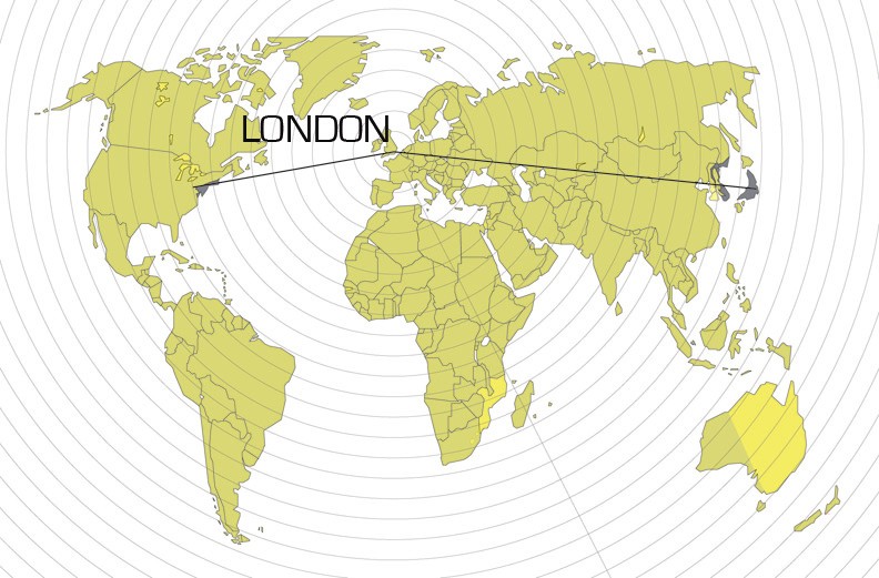
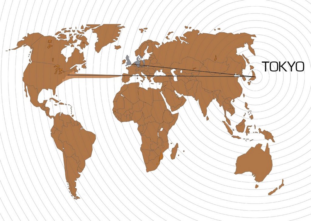
The following three maps show the transformation of the map in the fourth dimension with the global tunnel network implemented. The shift is very subtle, but it is an interesting exercise. These maps were generated in the same manner that the travel time maps were in the mapimation phase. The gray underlaid map is the geographic map. The colored map is the world mapped according to time.


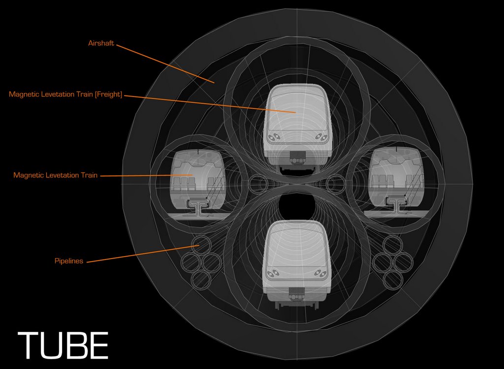
Program:
  • Railway for freight transport,
  • Maglev passenger train railway (max speed 361 mph),
  • pipelines for fluid and aggregate transport,
  • airducts and ventillation shafts that penetrate the surface above the tunnel,
  • maintenance shafts
Advanced modeling tools:

I am using morphing to create animations of maps that show how the proposal affects travel time. I would like to try morphing a globe I have modeled, but I am still trying to find the best way to do this. So far, the move mesh tool hasn't been too helpful.

Here is a Quicktime VR of a wire frame globe with the tunnels in place:
http://people.clemson.edu/~nathana/earthwirefmz.mov

Here is an animation of the above, slightly altered.


Using a perfected 3d globe, I would like to eventually use the same morphing techniques used in the mapimation to show how the tunnel effects travel time.

For the final review, I think it would be nice to have at least one or two critics in person while Ron and any other critics are connected with Skype and video, like we do when we have group conferences. I think speaking in person with the reviewers would result in better communication, clearer understanding, and more interactive questions. We could project our computer screens with a projector to present to those online and those in the room simultaneously.

Friday, November 17, 2006

Research 11-17-06

Some research:

Mag-lev trains: 310 mph

Deepest hole: 40,000 ft, 7.6 miles
http://www.gi.alaska.edu/ScienceForum/ASF7/725.html
http://en.wikipedia.org/wiki/Kola_Superdeep_Borehole


Earth's Crust: 20 miles, (less under ocean)

Straight Line Through the Earth from NYC to Tokyo: 6,971 miles
....London to Tokyo: 5,945 miles
....NYC to London: 3,502 miles

Longest Railroad Tunnel: Seikan Tunnel, Japan. 33.5 mile railroad tunnel
Longest Tunnel: Channel Tunnel. 31 mi, 24 mi under sea. 7 years to construct.


World's Deepest Tunnel: Eiksand, Norway. 287 meters deep. 7,796 meters long
Proposed: 24,200 m (15 miles)--Rogfast, Norway. Deepest Point: 383 m below sea level


World's Deepest Mine: East Rand Mine. 3.5 km below surface

Wednesday, November 15, 2006

Global Subway Charette

I have decided to continue with the idea of a subterranean global subway. I would like to integrate the idea of place not dependent upon location (see Archigram's walking city and the Helicopter Archipelego). Thus, I propose a tunnel network where there is a meeting point at the halfway point between the cities that are a part of the network. This meeting point or rendevous location would be a place where business and diplomatic meetings could take place on a moving train that would open up to the other country's train to allow access and interaction between the trains while moving. Two tunnels with high-speed freight trains would divert from the main tunnel to overpass this intersection. The rest of the main tunnel would house pipelines, airducts, and maintenance shafts. Air shafts would be installed at intervals along the path of the tunnel to provide ventillation.


I am researching the technology currently available to create a network of this size, and I will try to apply this to the design as much as possible, but I suppose some of it must be left up to the imagination.

Thursday, November 09, 2006

Global Network Archipelago: Thoughts on Proposal

Abstract:

The new world I propose is a world where a super-fast Global Subway Network joins mega cities to create one unified Global Metropolis. The parameters of this proposal are Global Cities--initially London, NYC, and Tokyo, with opportunity for expansion to include other mega cities. (Wikipedia's definition of a global city will be used--a city that has a "direct and tangible" impact on global affairs or significant cultural, political, and economic influence.)

Questions to be addressed (adapted from project statement):

1. How is my research an argument for my proposition?
I infer from my mappings that in "time space," larger, more influential cities, such as London, NYC, and Tokyo are significantly closer to each other than other smaller, and less-influential cities. This seems to be related to the number of direct flights to the cities and the frequency or volume of flights to the cities. I also speculate that this nearness in time space is a visualization of the cities relatedness in terms of politics, commerce, and culture.

2. How does it define site, program, strategy, and speculation for design?
I speculate that in the future, these global cities will become closer and closer in time space as the close relationships between the cities allow them to develop technology that will allow faster travel. Thus, my proposal is a prediction of a future world where economic and political centralization (maybe a World State) allows for the organization of mega-scale projects connecting cities across the globe.

3. What are the social, cultural, economic, political or other realities of this new world?
I envision a Global Metropolis where subways provide direct connection to cities across the world. For example, a person in NYC would take the subway to Time Square and from there switch over to the Global Subway (which is integrated into the existing infrastructure) towards Tokyo and arrive within, say, 45 minutes--enough to give the feel of leaving the country (at least in our present perspective of travel time). This would mean that business would be streamlined and cultural interchange could occur-- most likely resulting in a highly efficient economy, but a greatly homogenized culture. (My vision is of dystopia.)

4. What is the program-form and how is its generation a reaction to your research and how is it generated?

The program consists of a massive tunnel network that connects London, NYC, and Tokyo. The tunnel is drilled directly through the Earth's crust (and possibly its mantle and core), in a straight line to decrease travel-time. The tunnel consists of a hard shell that protects two train shafts. Pipelines fill out the rest of the shell as well as a maintenance shaft. This tunnel would possibly break up into smaller tunnels as needed to be integrated into the city's metro systems. A project of this scale could only occur under the organization of a centralized government or union (of the concerned nations) that would be able to maximize and implement the resources needed for completion.

Next Steps:

Research:
  • tunnels,
  • earth's interior structure,
  • high-speed trains
Strengthen weak areas:
  • jump from time map to Global Subway proposal (what do global cities have to do with travel time? why the shift from air travel mapping to a subway?),
  • research of factors that affect travel-time (jet streams, air embargoes, others?)

Critique: are there other, better proposals or speculations that could be revealed from the mapping?